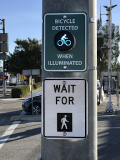
What would you think of an app that signals your approach at an intersection?
Well, the city of Santa Clarita, California--in partnership with Sensys Networks Inc--is piloting such a system along the Chuck Pontius Commuter Rail Bike Trail (Say that three times fast!), which parallels Soledad Canyon Road.
The system consists of a GiveMeGreen! smartphone app, which allows cyclists to be detected 300 feet in advance of an intersection. Once detected, the app's signal applies the normal timing function for pedestrian crossing. This lets pedestrians and cyclists use the same signal phase and "will not cause any delay for motorists," according to a Santa Clarita Gazette report.
While that stated purpose both intrigues and troubles me, I think there might actually be a benefit for cyclists: Motorists are often confused when they see pedestrians and cyclists at intersections, especially if pedestrians are crossing by one signal and cyclists another--or are following the same signals and timing as motorists.
It seems that half of the new system already exists on Soledad Canyon Road: There are bicycle- and pedestrian- only signs to alert turning motorists that cyclists and pedestrians could be crossing the intersection. This system has a bicycle-only light to tell the cyclist he or she has been detected. From what I understand, however, these lights are not connected to an app: Apparently, they rely on cameras or some other detection device at the intersection itself.
I would be interested to see whether this app and its system actually makes cyclists safer when crossing intersections--which, I believe, is the most perilous thing we do, especially if we are crossing a roadway intersection from a bike lane. Then again, I am not sure of how detectable I want to be--or, more specifically, of who I want to detect me, and from where--while I'm riding!

