Showing posts sorted by relevance for query railroad. Sort by date Show all posts

08 January 2021

From The Heights To The Cutoff—And Joe

Sometimes, when I ride through the industrial areas of Queens and Brooklyn, I feel like an archaeologist.

Tuesday afternoon I took Negrosa, my vintage Mercian Olympic, for a spin along some landmarked blocks in central Brooklyn.  I hadn’t planned to ride anywhere in particular; I just found myself spinning my pedals out that way.  

Brooklyn has, probably, the greatest concentration—and some of the best examples—of brownstone houses. Long-since-gentrified (and bleached, if you know what I mean) neighborhoods like Park Slope and Carroll Gardens regularly (during non-pandemic times) witness throngs of architecture students and tourists savoring the details of those buildings.  But some equally-beautiful areas like Stuyvesant Heights are less known because they are “off the beaten path. Stuyvesant Heights is still mainly an African- and Caribbean-American neighborhood.  Hmm...Could that be a reason why tourists (or White New Yorkers, except for those in the know) don’t beat a path to it?

These houses on Decatur Street have details even more intricate than what I saw every day when I was living in “the Slope.” 


I would love to see this neighborhood to keep the characteristics—including some interesting shops and cafes—that make it worth seeing.  But I hope it doesn’t turn into a masoleum, I mean museum or, worse, a Brownstone Theme Park.

Likewise, I could see this railroad underpass—under which I passed on my way home—turning into what many of us hoped the High Line would become.  The Montauk Cutoff, as it’s called, bears striking resemblances to The High Line before it became  catwalk for the well-heeled high-heeled:  Like the HL about 20 years ago, the MC is a weed-grown railroad right-of-way previously used by freight trains making deliveries to and from an old industrial area that’s starting to de-industrialize.


As I understand, the MC belongs to the Long Island Rail Road. (Yes, the LIRR still spells “Rail Road” as two words, just as they did in 1834!) Some reports say the Rail Road wants to add some trackage and connect it to their recently-expanded Sunnyside Yards.  Others say it’s structurally unsound and will be torn down.  Then there are stories that some city or state agency or investors want to acquire it and create a High Line, especially since some of the industrial sites could become upscale residential and commercial areas.

Me, I’d love for it to become a High Line for the people. It would include a bike lane (of course!), green spaces and art studios, galleries, craft shops, educational centers and cafes that could represent the many communities of Queens, the most culturally and linguistically diverse county in the United States, if not the world.

(Examples of the diversity include members of Central American indigenous groups who may or may not speak Spanish and Africans who might speak Wolof or some other native language and practice a religion far older than Christianity or Islam.)

Hmm...If someone takes me up on my idea, there might be a plaque or something with my name and likeness. Perhaps someone would look at it and wonder who, exactly, Justine was


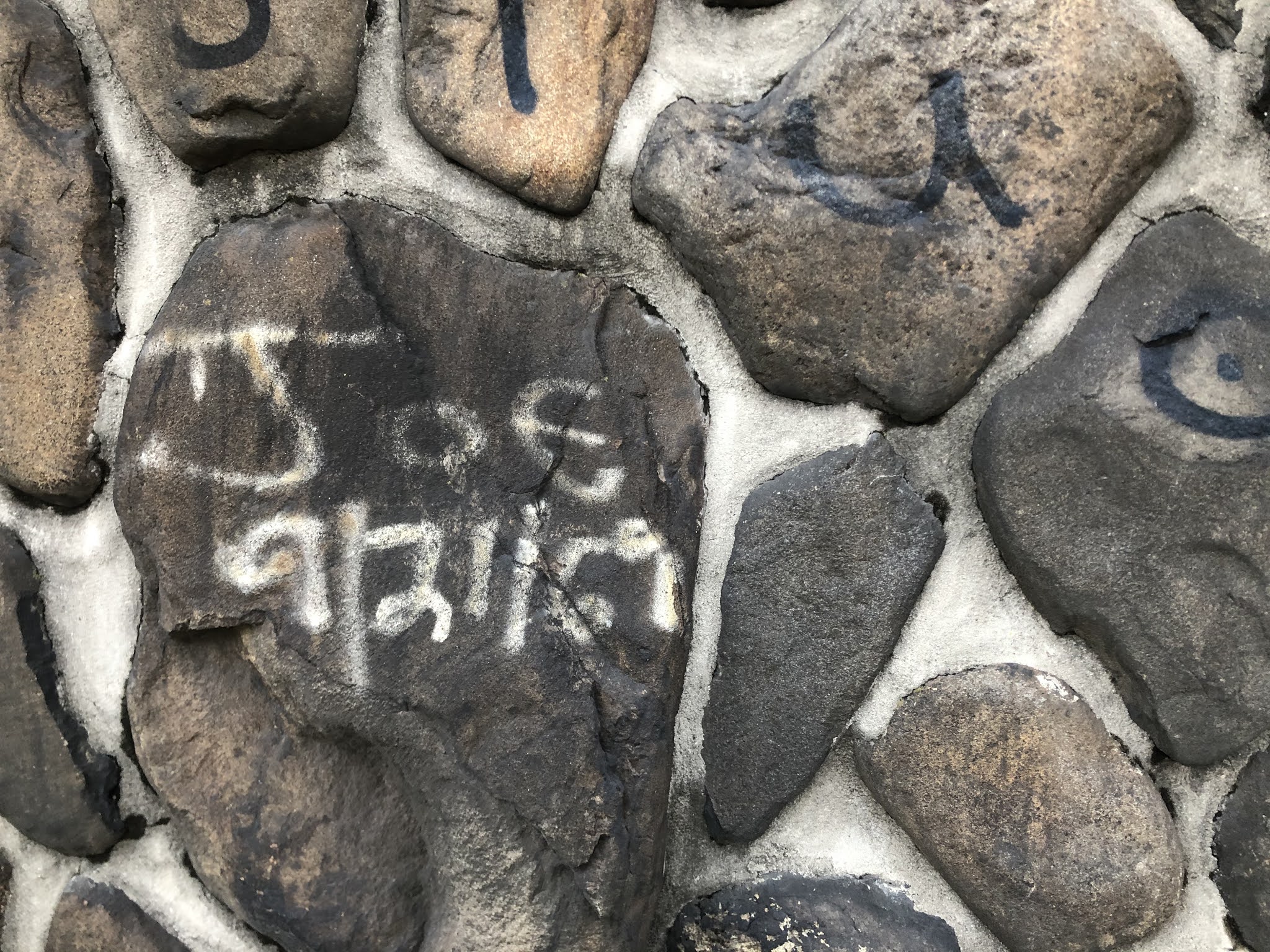
just as I wonder what happened to Joe, or whether Marty and Janet stayed together. I mentioned these bits of graffiti on the Review Avenue wall of the Calvary Cemetery eight years ago.  I first saw it many years ago—if I recall correctly, with my family, on our way to visit relatives who were living in Queens.

I never know what I’ll unearth on a ride!


15 September 2012

Train Tracks To Bike Paths?


Today was one of those crisp, clear, early-fall (though the calendar still says "summer") days that just makes me want to follow roads just to see where they'll lead.


In this case, I found myself following railroad tracks.  Oh, I've passed by or over them hundreds of times before.  But, just for fun, I decided to see how much I could follow them.

This one starts at the East River, and, within about a mile, passes under the Greenpoint Avenue Bridge of disappearing-bike-lane infamy.  It continues through along Newtown Creek, through a heavily industrialized area of Queens.


However, it's possible to follow it only for very short stretches.  Some of the land adjacent to the tracks is private property (factories, garages and such) that is closed off to the public.  And there are other stretches where the only way to follow the tracks is to ride on them. I've ridden on railroad tracks before--with a mountain bike.  


Apparently, the track is owned by New York and Atlantic Railway, which provides freight service on current and former Long Island Rail Road (Yes, it's spelled as two words!) tracks and right-of-ways.  One stretch of it--from about 43rd to about 58th Streets--seems to be used, at least on occasion, as it seems to be connected to another series of tracks and it's near UPS and FedEx terminals (and the Thomas' bakery!).  But other parts, such as the spur along Flushing Avenue and 56th Street, seem not to have been used in decades.


If New York and Atlantic indeed owns all of the tracks I've shown, I wonder whether they plan to use them.  As industrialized as those areas around the tracks are, there's still not as much as there was, say, during World War II.  And much of the freight is carried by trucks rather than trains, as there are highways nearby.


So...If NY and A doesn't plan to use the tracks, I wonder whether they'd sell, or even give, them to the city or state. If they did, I think the tracks and the adjacent paths and roads would make some great bike lanes.   I think now of the lane built by the Concrete Plant Park in the Bronx; I think something on a greater scale could be done with those tracks.  The effect would be similar:  Bike lanes that traverse some interesting urban-industrial architecture that takes on a unique beauty in the light of autumn foliage.


28 September 2012

From Motor Parkway To Bike Lane

In France, I did most of my cycling on Routes Departmentales.  They are designated with "D" or "RD"  and a number on road signs and Michelin maps.

Route Departmentale 618 in the Pyrenees, which I cycled in 2000.


The Departmentales wend along rivers, climb mountains and transverse sunflower fields, vineyards and all manner of verdant landscapes and villages in every part of the country.  Most were built early in the late 19th and early 20th Centuries; a few were built by paving over roads that date to Roman times.  

They were constructed while bicycling enjoying enormous popularity and as the automobile was in its early stages of development.  As automobiles became more common (though still not as common as they were becoming in the US), a new system of roads--Routes Nationales--made their way through the country and connected the cities.  The Departmentales then fell into disuse in many areas.

A similar process occured during the 1950's and 1960's, when Autoroutes were built to connect the cities.  Then, even more Departmentales lost whatever traffic they previously had.

Although not intended as bicycle lanes,  Deparmentales became wonderful venues for two-wheeled travel through the French countryside.  In spite of how little traffic most of them see, they are remarkably well-maintained.  Many of them run more or less parallel to Nationales or even Autoroutes.  So, getting around is relatively easy, even for someone who is as navigationally-challenged as I am!

I was thinking of Departmentales when I came across this photo taken in July 1939:


No, they're not in the Dordogne.  They are commemorating the conversion of two and a half mile stretch of the Long Island Motor Parkway--which had been closed down three months earlier--into a bike lane.  

Financier and railroad mogul William K. Vanderbilt Jr. built the Parkway early in the 20th Century as a racecourse.  By World War I, it had been turned into a toll road used mainly by wealthy socialites en route to their weekend and vacation homes on eastern Long Island.  However, after the Northern State Parkway opened in 1929, it fell into disuse and was closed three months before a stretch of it re-opened as a bike path.  

In time, about eight miles (13 kilometers) of the Motor Parkway would re-open as a bike path. It's a very pleasant ride that meanders through some of the nicest parkland in eastern Queens.  I sometimes ride the westernmost part of it--which ends near the Kissena Velodrome--during my commutes.  

What made it an innovative road when it was built is also, in part, what makes it a nice bike lane now.  In addition to having lovely settings, the Parkway was one of the first concrete-paved roads in the United States (Asphalt was not yet in use.) and the first to use bridges and overpasses.

In an earlier post, I proposed turning the roadbeds of no-longer-used railroad tracks in Queens, and other parts of New York, into bike lanes.  Now I wonder whether there are some similarly-disused roadways that could also be converted.  I can just imagine pedaling through the urban, industrial and pastoral landscapes of New York, and the rest of the country, the way I cycled along the departmentales in the French countryside.

25 August 2015

After Paris....A Ride In The Bronx?

Two years ago, the former chief of the French National Police caused a stir when he said that certain parts of Paris were starting to resemble the Bronx.

He was making reference to the increasing crime in those Parisian arrondissements--namely, the 18th, 19th and 20th.  (It also just happens that those neighborhoods contain the city's greatest concentrations of African and Middle Eastern immigrants.)  He is not the first Frenchman, or European, to make such a comparison:  the worst parts of cities, or the banlieues are often likened to New York City's northernmost boroughs, usually based on impressions gleaned from such films as Fort Apache, The South Bronx.  While I certainly wouldn't compare Port Morris with the Place des Voges, not all of the Bronx is poor and crumbling and even its worst parts aren't quite as dangerous as some other urban neighborhoods.  But I guess "Camden" or "North Philadelphia" or "The South Side of Chicago" doesn't have quite the same ring.

Anyway, there is a certain irony in the former police chief's comparison.   It can be seen in certain areas, such as a stretch of the Grand Concourse near Yankee Stadium where I rode today:


While the buildings are in need of maintenance, some are quite nice:  People actually lived in them by choice.  More to the point (for the purposes of this post, anyway), they bear the influences of Art Deco and classical architectural styles found in many Paris buildings.

Also, you may have noticed that the Grand Concourse, like the Boulevard des Champs-Elysees, is wide, has a parklike median and is lined with residential as well as commercial buildings. 

The parallels I've described are not merely coincidental.  At the end of the 19th Century, most of the Bronx was still wooded or farmland; all of its industry as well as most of its population was concentrated in the southernmost part of the borough.  But new waves of immigration would fill Manhattan's tenements and trains almost to their bursting point, and many longtime Manhattan residents sought bigger apartments as well as more open space but wanted a manageable commute to work.  The city's subway and trolley lines were extended into the Bronx, and new street and apartment buildings were constructed. 

Around this time, a man who had been a surveyor, mapmaker and engineer for the New York Central Railroad (then the second-largest corporation in the US, after the Pennsylvania Railroad) was appointed the chief  topographical engineer for New York City.  His name was Louis Aloys Risse. At age seventeen, he emigrated to the US from France, where he was born in 1850.  Thus, it comes as little surprise that while on a hunting trip (!) in the hills of the North Bronx, he conceived of a boulevard, inspired by the Champs-Elysees, that would connect one end of the borough with the other, and with Manhattan.

So...Do you still think it's so odd that I'd take a ride in the Bronx while still in the afterglow of my trip to Paris?


05 December 2018

This Isn't What We Mean By Track Riding

I admit that I grumble when a railroad crossing gate drops in front of me.  I guess I should be happy that such guards exist, though:


Surprisingly, that near-fatal encounter took place in Geleen---in the Netherlands, where we might expect such a crossing to be guarded, and a cyclist to know better.


Now I'm going to lecture you, dear reader:  Be careful at railroad crossings.  I admit, I'm saying so for selfish reasons:  I want you to come back and read this blog again.  Really, though, I don't like to see cyclists turned to road kill (track kill)?

05 September 2013

All Aboard The Bike Train

If you grew up in the US, or have studied American History, you know that the Underground Railroad isn't the New York City subway system and, in fact, has nothing to do with steel wheels screeching on tracks.

Likewise, a Bike Train isn't something Amtrak or any other railroad system has set aside for us.  It refers to a group of cyclists who ride, in a train, and are joined by other cyclists along the way.

I'll confess that I just learned about Bike Trains when I received a BikeNYC e-mail from Transportation Alternatives.  The cycling concatenation in question begins at the very upper end of Manhattan, near the Cloisters, and wends its way down the Hudson River Greenway to Midtown.  It departs at 8 on Friday mornings and is intended to provide "safety in numbers."

Bike Train in Brighton, England


More than two decades ago, I lived not far from the train's starting point.  Back then, they probably wouldn't have picked up very many cyclists until the caravan reached the area around Columbia University, nearly five miles to the south.  Or they may have had to go even further downtown before they had anything that could be called, without irony, a train.


02 September 2022

What's That Bike Doing On The Railroad Tracks?

 In previous posts, I've written about bicycles that ended up in the canals of Amsterdam, Paris and Brooklyn as well as rivers like the Tiber and even larger bodies of water like Jamaica Bay.

Probably the most common reason why bikes meet the same fate as mob victims in the Gowanus Canal (accordig to legend, anyway) is theft:  The perps don't know what else to do with the bike once they've used it for a getaway or joyride or realize that someone will recognize it, especially if it's from a municipal bike-share program.  Old bikes also get dumped when their owners realize what it cost to fix them, or they don't realize those bikes can't be fixed.  Or, people just want to get rid of them because they're disused and decaying.

Whatever the reasons, none can rationalize tossing a two-wheeler into the turbid or turbulent waters of a canal, creek, river, lake, bay or ocean.  Particularly indefensible is an incident that seems to be part of a pattern developing in Leeds and other parts of the UK.

According to a BBC report, vandalism, tresspass and other kinds of anti-social behavior have been on the rise in and around British railway facilities.  The Cross Gates station in Leeds seems to have been particularly hard-hit by such incidents, which include young people leaving or tossing bicycles in or alongside railroad tracks.


The incident shown in the surveillance video also reflects a particular ritual that seems to have developed around the practice:  One young person abandons  the bike on the platform edge before one of his peers drops it onto the tracks.

That sequence of events suggests, to me,  that it might be some sort of gang ritual:  The first young man might be leaving it for the other to toss in order to prove something or another.  Or, perhaps, the first young man simply didn't want responsibility if the bike-tossing caused injury or damage.

Whatever their motivation, no bike, no matter how inexpensive or ratty, deserves such a fate.

03 August 2010

Blood Under My Cleats

"Le sang coule dans les rues..."


Yes, I've ridden my bike in Paris--but not in 1572 or 1789 or 1871.  So I never got to see blood running in the streets, at least not in the City of Light.  


However, I did see blood running on the streets--and sidewalks--here:


To be precise, it was underneath the viaduct that I saw a thick crimson current.  Back in those days, the street scene looked more like this:


And one could see things that would turn him or her into a vegetarian on the spot:


I found this photo, and the one before it, on one of my favorite websites:  Forgotten NY.  The neighborhood shown in these photos is the Meatpacking District.  Ironically, it's now home to some of the trendiest shops and cafes in the city, as any fan of Sex and the City knows.


I rode down there today.  Actually, my doctor's office is a few blocks away and, after having my blood drawn, I ended my fast in the nearby park with tea and a corn muffin from The Donut Pub.  (I also bought a cherry donut for later in the day. I guarantee you that if you ever go there, you'll never even look at a Krispy Kreme again!)  


Fortunately, I didn't see any animal offal before or after consuming my impromptu brunch.  But, as I rode, I recalled a time when I was riding back from New Jersey.  Just after I got off the Staten Island Ferry, it began to rain.  The rain grew heavier as I pedalled up West Street and, finally, when I could barely see where I was going, I ducked underneath the viaduct you saw in the first photo.


I had just begun to ride with Look road pedals.  Those of you who ride them know that those cleats, like most road racing cleats, aren't made for walking.  I unclipped my left foot and touched down on the sidewalk--actually, in a pool of blood on the sidewalk.


The cleat at the bottom of my shoe was nearly smooth and flat.  It could just as well have been covered with grease.  My foot slid out from under me and I landed on my side--in another pool of animal blood.  When I got back up, I saw that my left side was covered with it, and it had spattered me on the front.  


Being covered with blood that is not your own is disconcerting enough. But what really upset me was that it ruined my favorite jersey I owned at the time:  a replica of the one Bernard Hinault and Greg Le Mond wore in the 1985 Tour de France.


In those days, I was skinny and could get away with wearing it!  


When the rain let up, I continued riding.  Eva had been visiting some friend of hers who didn't like me, and I didn't expect her to be back at the apartment when I arrived.  


"What the hell happened to you?"


All I could do was laugh.  Trying to explain it made me laugh even harder.  Soon, she couldn't help herself, either.  And, in one of the nicer surprises of the time we were together, she actually bought me a replacement for it.   


Every once in a while, she'd go for a ride with me.  I can guarantee you, though, that we never went to the Meat Packing District.  And we never walked or rode on the viaduct--which,in those days, never looked like this:


Now it's called The High Line.  It's supposedly inspired by the Viaduc des Arts in Paris, which, like the High Line, is an abandoned railway.  The High Line does have some nice flora and fauna tucked in among cafes that serve hundred dollar plates of spaghetti.  And   cycling isn't allowed on it.


Back in the day, one might have seen something like this on the Line:


When I was young (believe it or not!), the New York Central, which gave its name to Grand Central Station, was the second largest railroad in the country.  The Pennsylvania Railroad, for which Penn Station was named, was the largest. (It was once the largest company of any kind.)  But they, like most American railroads after World War II, were in decline.  So, someone had the bright idea of combining them into a company that would be "too big to fail".  The marriage was consummated, so to speak, in 1968; it lasted all but two years.  When Penn Central failed, it caused a crash on Wall Street and nearly brought down the US economy with it.


I know, banks and brokerage houses are different.  But you'd think that among all of those people with fancy degrees, someone would've remembered at least that much economic history.


After I finished my corn muffin and tea, I continued riding.  At least that's one thing nobody forgets how to do.  And there was no blood to clean afterward!

14 March 2020

At The Right Angle

In a few posts, I've complained about poorly-conceived, -designed and -constructed bike lanes and paths.  They lead to nowhere and expose the cyclists to all sorts of hazards.

Sometimes those hazards are embedded in the lane or trail itself.  Among the worst are railroad tracks, especially if they run parallel (or nearly so) in proximity to the cycling route.  Ideally, tracks and lanes (or paths) should cross at right (90 degree) angles or as close to it as possible. 


If the tracks cross at a more oblique angle, the  tires can graze against the rails, or get lodged against them, and send the cyclist tumbling to the ground.  That's happened to at least half a dozen riders on the Centennial Trail where it crosses the Burlington Northern-Santa Fe tracks in Arlington, Washington, 64 km north of Seattle. At that point, the trail crosses the tracks at an angle of less than 45 degrees--or near the one o'clock position.  (A 90 degree angle crosses at the 3 o'clock position.)

Recognizing the problem, the Arlington City Council has just awarded a contract to realign the trail so that the trail, which heads north, would turn east about 15 meters (50 feet) from the tracks so that it can cross at a 90 degree angle.

City engineer Ryan Morrison says the project will take about two to three weeks, and that it will timed to coincide, as best as possible, with improvements Burlington Northern-Santa Fe has planned for that same area.  That means the work will start around late May or early June.


07 April 2023

Little Town, Little Criminals

Ask newspaper writers what annoys or frustrates them most, and the answers will include headlines.  My newspaper articles certainly weren't masterpieces of literature, but it drove me crazy when it was led off with something illiterate, clumsy or simply inaccurate.

So I felt for Nicole Rosenthal, a staff writer for Patch.  Her otherwise-good article began with a title that, while it caught my eye--for a reason I'll mention in a moment--it set a very different tone than, I believe, Ms. Rosenthal intended.

"Aberdeen, Matawan Kids Are Violating Bicycle Laws, Police Say." Matawan is a village in the northern Monmouth County, New Jersey township of Aberdeen.  Until 1977, the whole township was known as Matawan.  Just one township--which, like Matawan, includes a few villages--stands between Aberdeen and Middletown Township, where I spent my high-school years and first became a dedicated cyclist.  In fact, some of my early two-wheel treks outside Middletown took me through Matawan and Aberdeen.


(Snark alert) Li'l Lawbreakers!  (Photo by Rachel Sokol)

Then, as now, the township's and village's streets, aside from Routes 34, 35 and 79, are lined with neat homes of people who commute to New York (the railroad station is one of the busiest in New Jersey) and their kids who are like suburban kids in other places--which is to say that if you take away their electronic devices, they're probably not so different from the kids I knew in Middletown.

According to the article, police have received "numerous" complaints about children "disregarding" the state's bicycle safety laws.  Well, since most young people don't think very much about the laws are--if, indeed, they even have a vague idea of what they are--I don't think they "disregard" them.  Perhaps "violate" is a better word:  After all, people violate all sorts of laws and rules they don't realize they're violating.   

So what sorts of laws do the youngsters of Matawan-Aberdeen violate? Well, from what the article says, some weren't wearing helmets, which the Garden State requires for riders under 17 years of age. (No such law existed when I was that age; in fact, people would look at you askance if you wore a helmet.)  But the majority of complaints were about kids riding in the "middle" of roadways.

Indeed, the law in New Jersey, like its counterparts in most jurisdictions of the United States, says that cyclists have to right as far to the right as possible.  (If that's an attempt to influence our politics, it didn't work with me! ;-)) So, I guess some people would define any other part of the road as "the middle."  If that's the case, were the kids endangering themselves or holding up traffic--or popping wheelies, as kids have been doing for about as long as they've been riding bicycles?  

(If they were riding in the "middle" of the road on Routes 34, 35 or 79, people wouldn't have been filing complaints; they would have been filling out hospital forms or making funeral arrangements!)

Anyway, I saw the headline and wondered whether that town where I rode past other kids like the one I was in Middletown--white, suburban and, if they were anything like me, rather docile even if they were capable of being smart-asses--was suddenly turning out menaces to society.

11 October 2015

Bridges, Islands, Art, History, A Canal And Smoked Beef

Two days of cycling in Montreal and no one has beeped a horn in anger or aggression at me.  And no driver has cursed at me.  (Yes, I know when I'm being cursed at in French!)  And, where bike lanes cross into traffic, drivers actually stop for cyclists, even when there's no sign or signal telling them to do so.  


I guess all of this is remarkable to me because I've cycled so long in New York.  What's most telling to me, though, is that most Montreal drivers have no more experience of cycling than most drivers in New York, let alone the rest of the US, have.  The drivers in Paris were good, but I suspect a fair number of them, if they're not currently cyclists, recently rode bikes on a more or less regular basis.

One thing I can't get over is how, where the bike lane of the Jacques Cartier Bridge crosses the exit for Ile Sainte Helene, drivers not only stopped, they didn't creep into the intersection--or drive into it and expect you to pick up your speed and get out of their way--the way many New York drivers in New York, and the rest of the US, do.


Yes, I did ride over the Pont Jacques Cartier--to Ile Ste. Helene, as I mentioned, and from there to the South Shore of the St. Lawrence River.  This time, I took the east walkway/bike lane because, well, it was closest to where I had been riding.  One of the first things I realized was that I was rolling on an asphalt service; the last time I pedalled across the Bridge, my tires buzzed on the grating that separated them from the St. Laurent, 400 feet below.  


It was then that I recalled that the last time I rode across the bridge, I was on the west side.  No matter.  I was out to enjoy the ride, and the city.


The last time I saw the island--and its "twin", the Ile de Notre Dame--they seemed to be relics of the Terre des Hommes exhibit of Expo '67.  Since then, a lot of landscaping and other work--including, ironically, the building of the Montreal Casino an Notre Dame.  But it's far enough over on the island that it's possible to, if not notice it, at least not get too close to it.


Since I last saw the islands, the city has done, I think, a nice job with them--creating bike and walking paths, fixing eroded areas and creating botanical gardens and the Biosphere, among other things.


Today there were two events that closed off parts of the islands.  One was a cyclocross race.  I didn't mind that one:  The circuit, on dirt paths, didn't interfere with anything else. But the other event closed off access roads and made it dificult to get back on to the Pont.  But I, and others, managed.


Along the South Shore--mainly in the suburb of Longueuil--there's a series of bike lanes that takes you from the bridge, though residential neighborhoods, between a highway and series of railroad tracks (not as bad as it sounds) and through local parks.  

Then, after getting back into Montreal, I picked up some excellent Quebec goat cheese and something from France that seemed to be a cross between Brie and Camembert, with more of a grayish outer rind.  It was one of the creamiest cheeses I've ever eaten!  I washed them down with some little yellow grape tomatoes I picked up from a farmer's market.  Later after wending through some streets in Old Montreal and the area around McGill University, I would eat some succulent raspberries, purchased from the same market, 

Then I rode up Rue Amherst (How did a street in Montreal get a name like that?)  to a place called "l'Ecomusee du Fier Monde". Located in a former public bathhouse,  the Ecomusee states that, as part of its mission, it aims to teach people in the community about its history as a way of empowering them.

The upper level of the museum had a show describing the rise and fall of industry in the Cetre-Sud area of Montreal, and the lives of workers during that time.  It's interesting, even if you're not from the area.  The lower level, on the other hand, hosted a exhibit on "Art of Imagination". I liked the idea better than most of the actual paintings, which were a bit too New-Agey for my tasts.

After that, I descended la rue Amherst to Old Montreal and the beginning of a bike path along the Lachine Canal.  Said canal was built to avoid the rapids in the St. Lawrence River, and was thus one of the most heavily-used canals in the world.  The opening of the St. Lawrence Seaway and the rise of interprovince trucking caused the canal to fall into disuse.

This is where the canal rejoins the river:


When you look at how wide the river is, you understand why, at one time, Montreal was the second-biggest port city in North America.  


As you can imagine, all of the riding I've described made me hungry.  So I pedaled up Boulevard Saint Laurent for this:


We were all waiting to get into Schwartz's, renowned for its smoked meats, especially in sandwiches.  I got their signature item:  a smoked beef sandwich on rye bread with mustard.  It might be even more unhealthy than poutine, but it was worth every calorie and every globule of fat.  

29 April 2017

Review Of A New Bridge

No one will ever confuse Review Avenue in Long Island City with Route Departmentale 618 or the Golden Gate Bridge to Sausalito and Tiburon.  

I had only one opportunity to do RD 618 and one other for the iconic California ride because, well, each of them is about 6000 kilometers away (in opposite directions) from my apartment.  Review Avenue, on the other hand, is only about five kilometers away (at least via the routes I take), which is one of the reasons I find myself riding there at least a few times a year.

Although it's gritty, to be polite, it is visually interesting.  There aren't any really tall buildings there, which allows the sky to serve as a kind of diorama backdrop for the street that separates the First Calvary Cemetery Wall from the sooty brick and stone industrial structures.  That same street also looks as if it's going to sneak in under the Kosciuszko Bridge, but it makes a sharp left and leaves that job to the railroad tracks and Newtown Creek instead.


Until a few days ago, the Kosciuszko Bridge was the steel-girdered span that looks like an Erector Set project left out in the rain and soot.  It still is, but it's also that other bridge that looks like it's hanging by red and white shoestrings from a couple of concrete tombstones.  


Talk about "build it and they will come":  The new Kosciuszko is already congested with traffic--and the old bridge hasn't been closed!  A second stringed structure is supposed to be constructed parallel to the current one in two years.  I think cars are already lined up to get across it.


Actually, I rather like the look of the new bridge.  And it's probably easier to drive, especially a truck, across as it doesn't have the old bridge's steep inclines and terrible sight lines.  At the dedication ceremony, Governor Andrew Cuomo said he heard his father--three-term Governor Mario Cuomo--use expletives for the first time when he drove the family across the bridge.

Neither bicycles nor pedestrians were allowed on the old "Kos".  As far as I know, they won't be allowed on the new ones, either.  Then again, the bridges are part of the Brooklyn-Queens Expressway, where you wouldn't want to ride even if it were allowed!

The old bridge is falling apart.  But some things endure:


I wonder what Joe was thinking when he painted his name on the wall of the cemetery all of those years ago. (Maybe he's inside it now!) I'd love to know what kind of paint he used:  Anything that could withstand all of the fumes from the factories and trucks, along with the weather, must be pretty durable!